The Everest Region
At 8848m Everest is the highest mountain in the world. It might not be one of the world's most dramatic looking mountains but what it lacks for in looks it makes up for in sheer height. Ever since Hillary and Tenzing first climbed the mountain in 1953, hundreds of thousands of people have come to the Everest region to take a look at Everest and the surrounding Himalayan peaks.
The plan for our trek was to fly to Lukla, go up the Gokyo valley and then cross over the Cho La pass into the Khumbu valley where we would walk up as far as Everest Base Camp. To get this into perspective Everest Base Camp, which is where the mountaineering expeditions to climb Everest start from, is itself at a height of 5364m. In comparison Western Europe's highest mountain Mont Blanc stands at a relatively tiddly 4808m.
Of course height isn't everything. To get up Mont Blanc you have to climb on ice and rock. Just about anybody can stroll into Everest Base Camp given enough acclimatization time. In fact as our guide and porter Bhola mentioned he had once taken a 78 year old Canadian man up there. Clearly it was going to be dead easy!
The first challenge however was actually getting to the mountains. Theoretically September should be a fantastic time for walking in the Himalayas. The monsoon has drawn to a close while the tourist hordes have yet to arrive. Unfortunately this year the monsoon came very late to Nepal and on 12 September, the date that we were due to fly from Kathmandu to Lukla, it was still pouring down with rain.
Because the tiny planes that fly to Lukla are not equipped with much in the way of instrumentation the pilots have to be able to see where they are going in order to take off. We joined a group of unhappy tourists waiting in Kathmandu airport. As well as small groups like ourselves there were several large organized camping groups, complete with an extraordinary number of eggs in cardboard cartons.
After waiting for six hours our flight was cancelled and we went back to our hotel in Kathmandu. Determined not to squander our precious remaining time sitting at Kathmandu airport we decided to try once more the following day. If the flight didn't leave we would get a bus to Besisahar and walk the Annapurna circuit instead.
The next day didn't look very promising either. It wasn't actually raining but there was lots of cloud in the sky. We had settled down to eat some overpriced biscuits from the airport shop for breakfast when suddenly we heard our flight to Lukla being called. Within literally five minutes the plane was in the sky. I wasn't sure whether to be happy that we were on our way to the Everest region or terrified that we were now in a small plane in questionable weather conditions.
It turned out however that Lukla airstrip was free of cloud and the plane landed safely. As we got off we could hear sounds of clapping and cheering coming from crowds around the airport. Our plane was the first to land in six days! Just behind us another plane landed. Within a few minutes they were both up in the air heading back to Kathmandu with a full contingent of passengers.
"Wow", said a Dutch guy from our plane who worked in luggage handling at Schiphol airport in Amsterdam. "We think we are doing well if we can get the planes turned around in an hour".
Outside the airport were lots of young Nepali men hoping to get hired as porters. There were also plenty of wild haired and slightly feral looking western trekkers hoping to be able to get back home. As we walked up the hill, cloud swiftly crept up the valley and had soon completely covered Lukla airstrip preventing any more flights from landing.
Lukla is at a relatively modest 2840m. The whole first part of our trek however had been planned around our need to acclimatize to the increasing altitude we would experience. This meant lots of short and easy days to start off with, which didn't sound like such a bad idea.
Our first night's stop was Phakding, a village a few hours walk from Lukla. The countryside in the Everest region looked very prosperous. Actually with the cozy looking stone cottages, neat stone walls and tidy vegetable patches we felt more like we were walking through the Cotswolds than the Himalayas.
The next day as we followed the tree lined river valley up towards Namche Bazar, the most important town in the region, the villages became further spread out. We had to sign in at the Sagarmatha National Park Entrance and then walked up a hill until reaching a prayer flag clad suspension bridge high above the river. From here it was a long winding climb up to Namche Bazar at 3440m.
If we were feeling sorry for ourselves, then the sight of the porters walking up the hill to Namche put things into perspective. There are no roads in the Everest area, in fact the road ends at Jiri which is another seven days walk out from Lukla. As a consequence most goods, from silly things like beer and Sprite for trekkers to essential items like flour have to be carried in by porters.
The porters, often wearing flip flops as opposed to proper walking shoes, carry a basket on their backs which is attached by a strap to their foreheads. These baskets are usually piled up so high with goods that they end up towering up in the air above the porter. Each porter has a stout walking stick. At rest stops they don't take their baskets off but simply place the stick underneath transferring the load to the ground.
At this point Steve, whether out of curiosity, machismo or masochism I am not quite sure decided he wanted to try to carry the bag of our guide and porter Bhola. I should say at this point that whilst Bhola was carrying our bag, it did only contain the bare essentials for our trip as opposed to six crates of San Miguel and a drum of paraffin and so was not really to be compared to the loads of the other porters. Even so, once the things that Bhola needed for himself were added on it was a pretty heavy bag and Steve lasted all of about fifteen minutes carrying it up the hill.
We were pleased to eventually make it up to the Sherpa town of Namche Bazaar. The Sherpas, now world famous for their role in mountaineering, started immigrating over the mountains from Tibet around six hundred years ago and settled as farmers and herders in the Everest region. The Sherpa language is closely related to Tibetan. In fact in Tibetan, Sharpa means 'Eastern People'.
Many Sherpas have made relatively large amounts of money working for expeditions and running lodges for trekkers and mountaineers. Perhaps due to this money, Namche itself felt like a boom town. Construction seemed to be happening everywhere. In a labor intensive process, largely carried out by workers from other parts of Nepal, heavy stone blocks were being taken from the quarry by porters and then painstakingly hand chipped into the right shape. The resulting flawless stone work looked like something that the ancient Incas would have been happy to put their names to!
After staying the night in Namche we needed time to acclimatize to the new altitude. The next night's stop was therefore planned for the village of Khumjung a short walk above Namche at 3780m. When we woke up in the morning a huge range of mountains suddenly appeared in the mist above Namche but then swiftly disappeared again while we were having breakfast.
Walking up the hill to Khumjung felt pretty tiring at this altitude. Sir Edmund Hillary (the first man to climb Everest along with Tenzing Norgay) helped to set up a high school near Khumjung and we met quite a few students on their way back down to Namche after taking an exam. Unsurprisingly they all seemed to be in pretty good shape. The epidemic of childhood obesity in the UK would probably be solved overnight if British kids had to walk 6km a day to school up and down a massive hill!
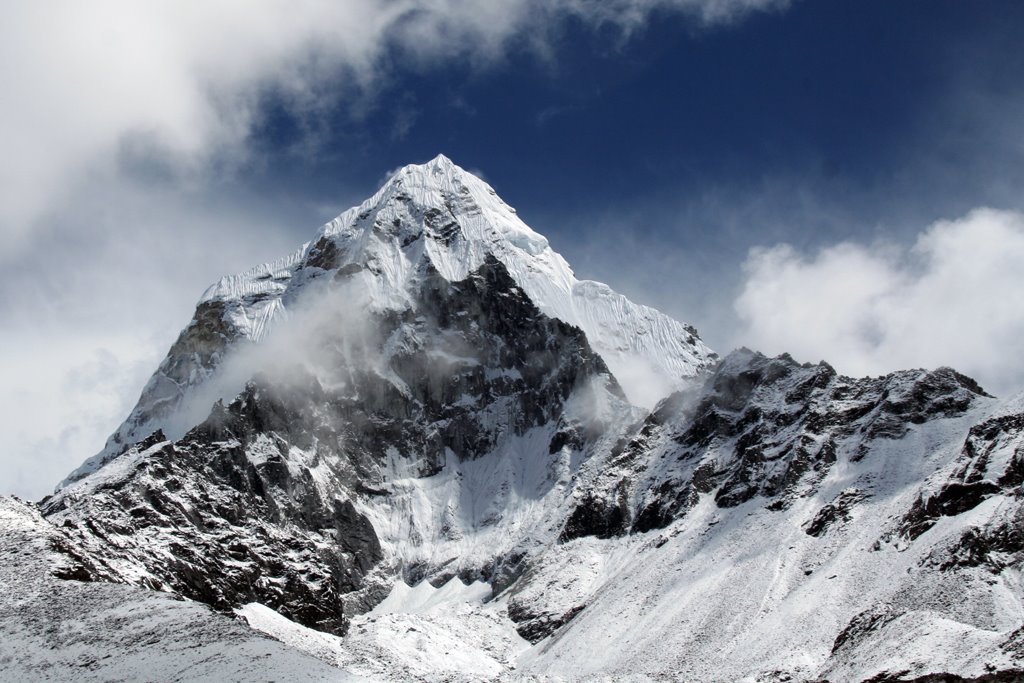
During the afternoon as we were relaxing in our lodge in Khumjung the beautiful twin peaked mountain Ama Dablam made a brief appearance through the cloud.
The plan for the following day was to walk up to Dole in the Gokyo valley. A mixture of sunshine and clouds allowed us to spot a few more mountains and it seemed as though the weather might be taking a turn for the better. Crossing a high point at 4000m Steve developed quite a bad headache (a common sign of altitude problems) so we decided to descend and spend the night at Phortse Tenga (3675m).
The first lodge we experienced at Phortse Tenga was on the more basic side of things. Noting the authentically medieval kitchen we decided to order boiled potatoes on the basis that they couldn't go wrong. We were then a little surprised to be served a big plate of potatoes still covered in both their skins and lots of mud. After removing the skins with Steve's penknife however they tasted pretty good. We then descended a little further towards the river where we found quite a nice lodge to spend the night.
After a short walk up to Dole (4050m) the next day we settled in for the afternoon. Going further would have meant going higher and we felt that it would be more sensible to take the increase in altitude nice and slowly. The scenery was starting to change in Dole. The trees were getting smaller with less agricultural land and yaks were grazing on the hillside.
To pass the time I started to read a book by Jon Krakauer called Into Thin Air. Within minutes I was totally mesmerised. It is the story, written by somebody who was there, of the disastrous 1996 climbing season on Everest in which more people died attempting to climb the mountain than in any other single year. The human story itself is so engaging that I think that even people with zero interest in climbing or Everest would find this book pretty difficult to put down.
I later discovered that Into Thin Air is actually quite a controversial book, mainly because Krakauer criticizes the behavior of some of the other people on the mountain particularly the Russian guide Anatoli Boukreev. As Boukreev risked his life to rescue three people from the middle of a storm near the top of Everest while Krakauer lay safely tucked up in his sleeping bag doing nothing, a lot of people think that Krakauer's comments are hypocritical to say the least! While I am inclined to agree with this point of view I think the book itself remains an absolutely gripping read.
Recovered from my late night mountain disaster reading session, the next day we walked on to a small place called Machermo (4410m). With the sun out, the logical next step was for everybody to start washing their clothes. The lodge owner provided us with plastic bowls and soon myself, three French trekkers who had been at the lodge in Dole, workers from the Machermo lodge and several guides and porters were all scrubbing away at an assortment of socks and shirts and table cloths. Perhaps inevitably as soon as the washing was hanging up, the sky darkened and it started to pour down with rain.
Fortunately the lodge owner decided to put the stove on. Although the stove was powered by Yak dung the chimney meant that it didn't smell at all. Soon due to an ingenious arrangement of chairs and trekking poles around the fire everyone's laundry was in a position to get dry.
The French trekkers had, in a very civilized way, brought genuine French whiskey and sausage up to the mountains with them. Combined with a large packet of Pringles they got a very nice pre dinner party going which they kindly let us join in. Feeling that we had to reciprocate their hospitality we bought a not so nice bottle of Everest whiskey to share around and went to bed a little tipsy.
I should say at this point that we had gained the company of a trekking dog. These are dogs that follow trekkers around the main routes begging for food. Not your usual scabby looking mongrels, I think that they are probably Tibetan Mastiffs. In any case they have beautiful thick brown and honey colored coats, presumably a prerequisite for survival in the Himalayan winters.
The dog that was following us was despite his beautiful coat painfully underweight and pathetic looking. Mindful of the notices at the entrance to the national park that warn tourists not to feed the dogs as they pose a hazard to wildlife, we resisted giving the dog any food for quite a long time. Finally however, Bhola cracked and sealed our fate by giving the dog some of my left over vegetable fried rice in Machermo.
The next stop was Gokyo (4800m). To get there we walked through an increasing barren and rocky landscape past a couple of glacial lakes. Gokyo itself was situated by the third glacial lake. There are two main reasons for visiting Gokyo, to climb the nearby Gokyo Ri view point (5340m) and to walk up to the fifth lake (5000m). From both these places there are fine views of Everest and many other Himalayan peaks.
The next day dawned bright and clear so we decided to walk as far as fifth lake. Unfortunately as we walked the sky started to cloud over and by the time we reached the fifth lake the clouds had obscured the top of Everest. We did however get some really good views of Cho Oyu (8201m) which appeared directly in front of us. It seemed surprisingly small looking for the world's sixth highest mountain!
The plan had been to climb Gokyo Ri the following day. However the weather had taken a turn for the worse during the night and when we woke at dawn the visibility was very poor. We decided that there would be no point in trying to climb Gokyo Ri and so had a bit of a lie in before walking across to Tangnag.
The path to Tangnag lay over the Ngozumpa glacier. The glacier was however completely covered by debris and there was no sign of the ice beneath. Interestingly enough, the dog didn't follow us to Tangnag. Presumably it knew we were on our way to the Cho La pass!
At Tangnag we settled in to a cozy lodge for the night. Up in the mountains many of the lodges are owned by Sherpas who have climbed Everest and used the money to open a lodge. Each time that they summit Everest, they are provided with a certificate by the Nepali government. These certificates are usually hanging proudly on the walls of the lodge dining room along with photographs of themselves astride the summit itself.
The next day we planned to cross the 5420m Cho La pass. We set out at six in the morning. The weather was cloudy but at least it wasn't raining or snowing. We climbed on a steep but not particularly difficult path as far as 5150m, being overtaken along the way by two Spaniards and then one Spaniard and an Australian woman.
After descending a couple of hundred meters the path started to rise again and suddenly became much more difficult. It had started to snow and we were climbing over lots of slippery and rocky boulders. I thought that this was bad enough until we started up a very steep slope of snow. The snow was quite deep and we kept falling over. The altitude also meant that we were feeling very tired. Fortunately we could follow the footsteps of the people that had gone in front of us.
I think that at this point we would have just turned around and gone back down had it only been the two of us. I didn't really feel like it was the type of walk that we were equipped for or should have been doing. However Bhola insisted that we should keep going and we eventually made it to the top of the pass.
Once up on the top of the pass sitting amid the fluttering prayer flags I felt absolutely hysterical. Steve was really tired and it was snowing heavily. The visibility was also very poor, approaching a total white out in fact. Not only could we no longer see the path back down the way that we had come, but in front of us there was a lake stretching out onto a glacier where it looked as though the path should have gone. Fortunately we could still make out the footprints of the people who had come before us leading up to the right of the summit and then down on to the glacier.
As we walked on to the glacier we had to jump over a crevasse, which could have been dangerous had the visibility been any worse. The snow on the glacier was knee high and I kept slipping over and having to get back up again as I followed the footprints down the slope.
Steve and Bhola were now apparently feeling happy and relaxed and stopped for a bit of a photography session in the snow. My mind was filled with the scenes from Into Thin Air where the ill fated Japanese climber Yasuko Namba and others waste the precious minutes before the storm breaks taking pictures on the summit of Everest.
"What are you doing", I screamed at them. "Can't you see that the weather is getting really bad? We have to go down now!"
On Everest they call the area above 8000m "The Death Zone" because the extreme altitude makes it difficult for people to survive. As far as I was concerned with our low level of experience and acclimatization, any mountain area above 5000m could potentially constitute our own personal death zone!
After abut half an hour we got off the glacier and started climbing down the rocky slope at the other side. At this point I started to feel much much calmer. We could see the Australian woman and Spaniard resting at the bottom of the slope. It turned out that they hadn't been so far in front of us after all. I figured it was the smoking Spaniard rather than the ultra fit Australian who had kept them down to our pace!
At the bottom of the rocks we stopped for a Mars bar and Chapati. We were now a couple of hundred meters below the pass and the falling snow had turned to sleet. Even better there was now a proper path leading down the hill, one that you could walk down normally.
After another couple of hours of walking in the rain we arrived at Dzonglha. The lodge here was an utterly miserable little place. Damp and dirty it looked no fun to stay in at all but we just couldn't face walking another three hours on to Lobuche. They did however put a fire on in the dining room and we managed to get dried out and warmed up.
Just before dark I was cleaning my teeth outside in the rain when a bedraggled looking young Chinese man staggered towards the lodge.
"Is this Dzonglha?", he asked.
"Mmmmmm", I said with the toothbrush still in my mouth and pointed him towards the lodge door.
It turned out that he had crossed the Cho La pass alone two hours after us. He seemed quite shaken by the experience, but fortunately had still been able to make out our foot prints in the snow and so avoided getting lost.
The area around Dzonglha is supposed to be incredibly beautiful. However when we woke up the following morning the weather had if anything taken a turn for the worse. Nuptse, Lhotse and Cottontail or whatever the surrounding mountains were supposed to be called, were stubbornly hidden behind blankets of black cloud.
After a breakfast of Snickers bars (the rotten eggs and reheated potatoes served up by the lodge proving to be inedible) we set off to Lobuche (4940m). After the previous day, walking to Lobuche felt like going for stroll around Battersea park. We quickly grabbed some lunch in Lobuche which seemed a bit of a depressing place and then started the walk up to Gorak Shep (5170m).
It was snowing steadily on the way to Gorak Shep. Just before the climb up on to the moraine of the Khangri glacier we ran into the Dutch guy who had been on our flight from Kathmandu, coming down the hill.
"Don't worry about the weather", he said. "I spoke to the climbers at Base Camp this morning. Apparently its going to clear up first thing tomorrow and they are already making plans to start ascending the mountain."
After a seemingly endless trudge up and down the moraine, the couple of lodges that made up Gorak Shep finally came into sight. Although very cold the lodge we stayed in was the height of civilized comfort in comparison to the previous night's accommodation at Dzonglha!
Gorak Shep is the highest place in the Everest region where you can stay if you aren't camping. You can walk up to Kala Pattar (5600m) for an excellent view of Everest and the surrounding peaks and also go to Everest Base Camp (5364m). Strangely from Everest Base Camp you can't actually see Everest! However you can see the Khumbu icefall, where the expeditions start their climb and you also get to say that you have been there.
Our plan if it was still snowing in the morning was to walk to Everest Base Camp. Unfortunately Steve had a headache and so it didn't make sense for him to go any higher. Bhola offered to take me by myself but I thought that there wasn't any point as we would all be going together the next day.
As wet and exhausted trekkers from a large organised group gradually straggled in from Everest Base Camp to our lodge in the late afternoon I felt that it had been a pretty intelligent day to pick as a rest day! We set our alarm for dawn the following day hoping that the weather would have cleared and we would be able to go to Kala Pattar. If it hadn't we would just head to Everest Base Camp instead.
Unfortunately, it continued to snow heavily all night and by the morning Gorak Shep was covered in knee deep snow. Depressingly even going to Everest Base Camp was now out of the question as crevasses in the glacier would have been hidden by the snow and the footprints of the previous day's group showing a safe route through would have been covered up.
The question was whether to wait another day hoping that the weather would improve or to start to go back down. The large organised group was about to go to Lobuche so if we left just after them we could follow their tracks. Otherwise if it continued to snow for another day we might just end up stranded in Gorak Shep!
In the end we decided reluctantly to go down leaving only two slightly eccentric looking bearded trekkers in the lodge, playing a game of chess. An English guy had told us that the mountaineers at Base Camp the day before had had a weather forecast predicting that the snow would stop falling at 10am that day. However thinking about the similar and totally wrong prediction that they had made to the Dutch guy two days previously I was pretty skeptical.
The landscape between Gorak Shep to Lobuche had been completely transformed. In fact covered in a thick layer of snow it was almost unrecognizable. Unlike our experience on the Cho La pass however I wasn't in the slightest bit worried. There was a clear and fairly busy path with people in front of us and behind us and we were heading down hill. In fact, although I wasn't tempted to have a snow ball fight with Steve in a lot of ways walking through the snow felt quite fun.
After a quick break at Lobuche we carried on down the valley towards Pheriche (4293m). On way down we passed a series of rock memorials to climbers who have died on Everest, including Scott Fischer who died in the 1996 storm that I had read about in Into Thin Air.
Gradually as we lost altitude the snow became very slushy and I fell over quite a few times slithering down the hill. Eventually as we approached Pheriche the sleet stopped. Then unbelievably the sky began to clear and Ama Dablam and Lobuche East appeared out of the cloud. It was 3pm. The mountaineer's weather forecast had been out by only five hours.
At this point we both felt pretty sick that we hadn't waited in Gorak Shep for one more day. Still there was no way we were going to climb up 1000m to get back up there so we checked into a lodge in Pheriche. Looking on the bright side of things the change in the weather might mean that we actually got to see some more mountains.
The lodge we stayed in was run by Pemba Sherpa whose Dad had once guided former American President, Jimmy Carter on a walking holiday around the region. As the only guests (I guess the flights from Lukla still weren't coming in) we were given Jimmy Carter's former room complete with a photo of him above Steve's bed.
Next to the lodge was the Himalayan Rescue Association Medical Post. Staffed during the peak trekking season it treats lots of tourists with altitude sickness and also provides medical care for local people. Outside was a tasteful looking stainless steel memorial. Naively, I thought it was a memorial to all the people who had died at the Medical Post. Instead it turned out to be a memorial to all the climbers who have died on Everest.
Pemba's lodge was the first one we had stayed in that felt really family run. We sat around the fire drying our socks while Pemba's dad spun yak's wool into thread. The star of the show though, was Pemba's cute eight month old daughter. A true Sherpa Princess she even had her own fur lined cradle.
The next day dawned clear and following Pemba's advice we tried to head up towards Taboche Base Camp in order to get a view of Everest. Although we could see Lhotse, the world's fourth highest mountain, very clearly and had great views of Ama Dablam, Everest was once again covered in cloud.
I was starting to think of seeing Everest as being like spotting a highly endangered species of animal in the wild. Was it really possible that we would end up spending weeks walking around Everest without ever seeing the mountain? Would Steve have to carefully photograph a postcard, Photoshop us into it and put it up on Flickr in an attempt to prove we had actually been to the Himalayas?
After a late breakfast we set off walking towards Tengboche (3860m). Walking in the sunshine the landscape gradually became less harsh and trees began to reappear. From Tengboche, a Buddhist monastery surrounded by several lodges, Everest could apparently be seen clearly on a fine day. By the time we walked up the steep hill to Tengboche in the late afternoon however, the whole area was covered in cloud.
The next morning, Steve got up before me and was soon hassling me excitedly to get out of bed. We had a perfect view of the mountains on all sides. Finally even Everest was there sticking up innocuously by the side of Lhotse.
After we had warmed up from the early morning photo session, we started the day's walk down towards to Namche. Now suddenly, everywhere we looked there were more incredible views of Everest and of the other mountains in the surrounding valleys.
Getting to Namche felt fantastic. Now that we could see the mountains it looked much prettier. We took a relatively expensive room with a shower in the nicest lodge we could find and got clean for the first time in far too long. My appetite was raging out of control and I ate beans and fried eggs and potatoes and toast and still felt hungry for more. Best of all I was able to briefly use the exorbitantly expensive satellite internet connection and discovered that my brother had had a little girl making me an auntie for the first time.
It now just remained to walk back to Lukla and catch our flight back to Kathmandu. The walk was longer than I remembered, perhaps because we did it over two days on the way up. Still at certain points I felt like I was suffering from Low Altitude Sickness. The sudden descent had left me teeming with energy and I almost couldn't seem to walk quickly enough to use it all up.
Coming the other way were hordes of tourists and porters and trains of yaks. By the suspension bridges traffic jams were starting to develop. Despite our bad luck with the weather it made me quite happy that we had chosen to come in September. At least we had had the snowy cloud covered mountains to ourselves.
As we flew back to Kathmandu the views of the Himalayas were magnificent. I felt quite sad though as we flew past. The adventures of the last year were now over and the routine of normal daily life would start up again in only a few days.
Tomorrow we fly back to London and so this is going to be the last entry that I write in this blog.
We have certainly had a fantastic time. If any one wants to get in touch in the future my email is natalie_dillon@hotmail.com.
posted by Natalie Dillon at 2:44 AM
4 comments
![]()
![]()